Indice National de Biodiversité : 0.308
| Catégorie | Espèces connues | Espèces menacées | % sp menacées |
| Plantes |
3164 |
2 |
0.06 |
| Poissons d'eau douce |
100 |
1 |
1 |
| Amphibiens |
11 |
0 |
0 |
| Reptiles |
97 |
2 |
2.06 |
| Oiseaux |
183 |
6 |
3.28 |
| Mammifères |
92 |
13 |
14.13 |
Une liste rouge existe : pour les plantespour les animaux.
Des activités de conservation ex-situ sont réalisées grâce à :
1 Museum(s) d'Histoire Naturelle 2 jardin(s) zoologique(s) 3 jardin(s) botanique(s) |
Human Impacts on the Biosphere | The Global Methodology for Mapping Human Impacts on the Biosphere (GLOBIO) aims to develop a global model for exploring the impact of environmental change on biodiversity. It supports UNEP's activities relating to environmental assessment and early warning. The advanced GLOBIO3 model provides an analytical framework for bringing together biodiversity and environmental change data. | | Powered by Zoomify |
|
|
Algeria comprend 8 écorégions| Code Ecoregion | Nom Ecoregion | Code Menace* | Surface % | | PA0513 | Mediterranean conifer and mixed forests | 2 | 0.17 | | PA1213 | Mediterranean dry woodlands and steppe | 2 | 3.13 | | PA1214 | Mediterranean woodlands and forests | 2 | 4.4 | | PA1321 | North Saharan steppe and woodlands | 2 | 20.89 | | PA1329 | South Saharan steppe and woodlands | 2 | 12.75 | | PA1327 | Sahara desert | 1 | 55.81 | | PA1332 | West Saharan montane xeric woodlands | 1 | 2.65 | | PA0905 | Saharan halophytics | 0 | 0.2 |
* : Menace codée : 4  (très forte), 3 (très forte), 3  , 2 , 2  , 1 , 1  ou 0 ou 0  (faible ou nulle). (faible ou nulle). | 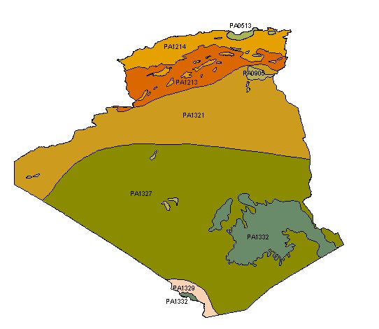
An ECOREGION is defined as a large area of land or water that contains a geographically distinct assemblage of natural communities. The WWF Conservation Science Program has identified 825 terrestrial ecoregions across the globe. Map and data have been processed from the Terrestrial Ecoregions GIS Database (Olson, D. M. and E. Dinerstein. The Global 200: Priority ecoregions for global conservation. Annals of the Missouri Botanical Garden 89:125-126). |
 Bilan national de la biodiversité