AFRICA PROGRAMME 2004-2007First Training Programme for Natural World Heritage Sites in Africa |
 Â Â Â Â Â Â
 Â Â Â Â Â Â
 Â Â Â Â Â Â
 Â Â Â Â Â Â
 Â Â Â Â Â Â  |
|
Latest RFE map available (period: 2006041-2006050) Image courtesy of FEWS Net Use the tool bar for zooming in or out the map. Mouse over for description of the alert and click for more information on the alerts. |
Legend :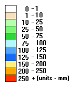 |
|
Meteosat Rainfall Estimation (RFE) imagery is an automated (computer-generated) product which uses Meteosat infrared data, rain gauge reports from the global telecommunications system, and microwave satellite observations within an algorithm to provide RFE in mm at an approximate horizontal resolution of 10 km. The main use of these data is to provide input for hydrological and agrometeorological models as well as to provide climate information e.g. compare the current state of rainfall with previous time periods. | |