![]()
Ce travail fait partie d'un projet de recherche destiné à
déterminer les milieux préférés par la marmotte en
fonction des disponibilités de l'environnement. Les recherches ont
été effectuées dans la Vallée de Brembana (province
de Bergamo). D'abord, les paramètres nécessaires à la
description de l'écologie de la population de la marmotte (altitude,
exposition, pente, ensoleillement) ont été identifiés et
les disponibilités du milieu mesurées. L'examen de la
distribution des colonies, en fonction de leur densité a permis
d'établir l'absence de préférences significatives quant
à l'exposition, l'altitude et l'ensoleillement. Par contre, le choix de
la pente est significatif. Les données de terrain montrent que les
marmottes n'aiment pas la forêt, et choisissent les terrains pierreux.
Elles préfèrent les milieux protégés par des parois
rocheuses et laissent la forêt en aval de la colonie.
Mots-clés : Marmotte alpine, Marmota marmota, Alpes Orobiennes,
vallée de Brembana, écologie, possibilités
environnementales.
This work is part of a research project finalised to determine the
environment preferences of the marmot, relating to the environment
availability. It took place in Brembana Valley (Bergamo district). In a first
step the parameters necessary to the description of marmot population ecology
(altitude, exposure, slope, sun-exposure) have been ascertained and the
environment availability have been measured. In the second stage data have been
collected in the field and compiled. Analysis of the colony distribution
relating to their density showed that there is no significative preference
about exposure, altitude and sunny places, but great difference is made by the
slope. Analysis of the data cards compiled in the field showed how these
animals do not like forest zones, but prefer stony places. They better
colonised environments which are sheltered by rocky walls.
Key-word: Alpine marmot, Marmota marmota, Orobic Alps, Brembana Valley, ecology, environment availability, ecological choices.
Donc, la densité réelle de la population (nombre de colonies par hectare de surface disponible) a été pré-cisée pour chaque paramètre (altitude, pente, exposition, ensoleillement). Les méthodes utilisées jusqu'alors, où l'étude de la distribution de la population fournissait des valeurs numériques ou des pourcentages non reliés aux disponibilités de l'environnement, ont été modifiées.
Altitude. 13 classes de 100 mètres d'intervalle ont été considérées, de 1300 jusqu'à 2600 m.
Exposition. 8 classes ont été déterminées : Nord, nord-est, Est, Sud-est, Sud, Sud-ouest, Ouest et Nord-ouest.
Pente. 3 classes ont été considérées : faible 0-10deg. ou 0-18%, moyenne 10-30deg. ou 18-70%, forte >30deg. ou > 70%.
Ensoleillement. C'est la cartographie du rapport de la durée pendant laquelle le soleil est au-dessus de l'hori-zon astronomique (Gisotti 1988). Prenant en compte la latitude du site, indépendamment de la situation climati-que, "le nombre normal d'heures de soleil dans l'année" (h.n.) à différents niveaux (Bartorelli 1965) a été calculé en superposant la carte des pentes à celle des exposi-tions. Des limites ont été choisies et trois classes prises en compte : faible ensoleillement <1800 h.n. ; moyen 1800< h. n.< 2200 ; fort > 2200 h.n.
Données de terrain. Sur la zone étudiée un dé-nombrement a été réalisé, chaque colonie localisée, et sa surface établie. Ces données ont été compilées sur car-tes. Pour distinguer l'extension d'une colonie, la distri-bution spatiale des terriers a été considérée : les limites du territoire ont été fixées là où il n'y avait plus que des terriers de fuite ; en milieu rocheux où il est difficile de déterminer les entrées des terriers, les déplacements des animaux ont été considérés. Pour chaque colonie, la valeur des paramètres écologiques a été déterminée. De plus, l'habitat a été décrit en considérant différents aspects : - de la végétation et de la couverture: arbres, arbustes, herbacé, rochers et pierres. Pour chacun un index de couverture a été établi : 1 = 0% ; 2 = 0-20% ; 3 = 20-40% ; 4 = 40-60% ; 5 = 60-80% et 6 = 80-100%. - des caractéristiques des entrées de terriers, la présence de poste de surveillance et la quantité de matériau issue du fouissement ; - de la présence, nature et position de barrières éventuelles telles que falaise, bois, torrent ; - de la pression humaine telle que pâturage, tourisme, installations humaines (nature et position).
Analyse des données. L'étude des données col-lectées permet d'obtenir des informations sur la distri-bution des colonies selon les différents aspects con-sidérés. Pour les 4 paramètres écologiques, 2 méthodes ont été utilisées : la première, basée sur la distribution de la densité effective, s'accorde au nombre de colonies présentes par hectare de surface disponible ; la seconde, statistique, met en oeuvre le test du Chi carré et le test de Bonferroni pour déterminer les limites de confiance et la significativité des valeurs du premier test. Ceci permet de cartographier la distribution des colonies dans chaque classe. Le même processus a été utilisé pour définir les caractéristiques de l'habitat des colonies ; pour chaque type de couverture, les cartes de distri-bution sont réalisées. Les informations concernant les entrées de terriers, la présence de barrières et de facteurs liés à la gène humaine ont été élaborées en tenant compte des pourcentages de colonies d'un type donné.
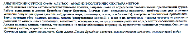
Altitude. La densité s'accroît entre 1800 m. et 2300 m., avec un pic entre 2200-2300 (Fig. 1), dû à la faible disponibilité du milieu. Le minimum de la classe 1700-1800 est significatif (c2 (7) = 16,0007; p < 0,05), cette classe est sous-exploitée. En effet, cette zone alti-tudinale est particulièrement fréquentée par les touristes, les automobiles et les skieurs. L'absence de colonies dans la classe supérieure est due à la faible disponibilité du milieu et aux besoins climatiques des marmottes.
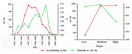
Pente. Le pic de densité correspond à la classe de pente la plus faible mais qui est aussi celle de la plus faible disponibilité environnementale ; de plus, une chute nette de la densité se produit pour la classe de pente forte (Fig. 2). Ce tassement et la valeur élevée de la densité pour la classe de pente moyenne sont signifi-catives (c2 (2) = 14,8764; p < 0,005), indiquant un choix actif de la part des marmottes.
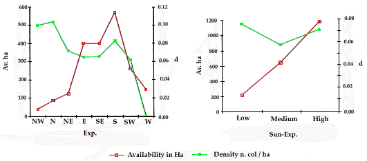
Exposition. Une forte densité correspond aux expositions Nord et Nord-ouest (Fig. 3). Elle peut s'ex-pliquer par le fait que certaines colonies s'installent sur le côté nord de la montagne où la présence humaine et le pâturage sont faibles et l'environnement de qualité pour la pente, l'ensoleillement et la couverture végétale. Mais ce pic n'est pas significatif (c2 (7) = 13,2958; p = 0,1). Il n'y a pas de relation entre la population de marmottes et l'exposition, en fait la courbe tend à être homogène, sauf pour l'exposition Ouest où ne se trouve aucune colonie.
Ensoleillement. La courbe de densité est prati-quement plate (Fig. 4), avec une valeur plus élevée dans la classe inférieure. il n'y a pas de relation significative entre l'ensoleillement et la distribution des colonies
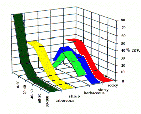
Caractéristiques environnementales. Les ani-maux n'aiment pas du tout les zones forestières et préfè-rent coloniser les espaces ouverts (Fig. 5), en réponse à des besoins défensifs. Le besoin d'un large champ de vision est confirmé par la courbe concernant la couver-ture en arbustes où la chute du pourcentage de colonies est moins rapide que dans le cas précédent. En effet, cette couverture est constituée de rhododendrons, gené-vriers et myrtilliers qui n'atteignent jamais des hauteurs pouvant obstruer le champ de vision des marmottes. Les colonies sont plus abondantes dans la 4ème classe (40-60%) de couverture herbacée. Les marmottes préfèrent un habitat riche en surface pâturable, et évitent les clas-ses inférieures où la disponibilité en nourriture est trop faible. Les classes supérieures sont peu occupées par les marmottes. Cela est dû, en particulier à l'exploitation par l'homme des meilleurs pâturages et à la difficulté à trouver un refuge contre les prédateurs. Les marmottes préfèrent les zones où les affleurements rocheux ne sont pas trop importants, pour satisfaire leurs besoins de fouissement. Mais la présence de pierres ou de rochers est favorable car celle-ci diminue la pression humaine et assure plus de refuges contre les prédateurs. Les bar-rières naturelles peuvent déterminer les limites des colo-nies. Les marmottes colonisent les environnements pro-tégés par des falaises proches qui assurent aussi des conditions microclimatiques favorables. Les bois sont évités pour des raisons défensives. Les torrents, peu im-pétueux, ne constituent pas une limite pour une colonie.
Pression anthropique. La compétition avec le bétail intervient non pour la nourriture mais pour l'es-pace (Panseri 1988). Les marmottes cohabitent avec le bétail et colonisent les milieux pâturés. En effet, ceux-ci offrent généralement une nourriture plus abondante et se trouvent dans les zones de pente faible ou moyenne, préférées des marmottes. Les installations humaines poussent les marmottes à coloniser des sites qui en sont éloignés et plus bas. Un pourcentage important (10%) de marmottes occupe les sites autour des "baite" (abri alpins) ou d'autres constructions inutilisées par l'homme. Le tourisme, surtout pédestre, n'affecte pas l'installation d'une colonie, le dérangement est passager et ne présente pas un réel danger. Au contraire, une partie des colonies s'intéresse au tourisme permanent, tel que pic-nic ou bain de soleil.
*****
| Figure 1. Altitude / Altitude | Figure 2. Pente / Slope |
| Figure 3. Exposition / Exposure | Figure 4. Ensoleillement / Sun-exposure |
The mountainous area considered in the different works on species ecology, have very different orographical, altimetrical, morphological aspects; further-more in a same area each ecological parameter has different environmental availability. It is not likely to compare the results of studies led in different areas or to extend on the neighbouring areas the results of a study, in order to determine their vocation, without introducing the relation between supply and demand. Then, the real density of the population (number of colonies per ha of available surface) has been determi-ned inside each ecological parameter (altitude, slope, exposure, sun-exposure). In this way the methods adopted up to now, where the study of the population distri-bution was finalised to obtain numeric values or percentages not related to the real environment availability, have been modified.
Map elaboration. In this first stage it has been used the Provincial Technical Map, drawn to a scale of 1/10,000, in order to show and to quantify environment availability related to the different ecological para-meters. After determining the limits of the study area, delimited upper by the orobical watershed and below by the upper boundary of wood, each uncolonizable sur-face has been excluded: rocky walls, sheet of water, little woodlands. Then, for each parameter useful to the description of marmot ecology, the classes of significa-tive values and their map-representation have been established; the environment availability have been measured by using a planimeter.
Altitude. 100 m intervals have been considered for a total amount of 13 classes, from the 1300 up to 2600 m.
Exposure. 8 classes have been considered: North, North-East, East, South-East, South, South-West, West, North-West.
Slope. Three classes have been considered : gentle slope 0deg.-10deg. or 0%-18%; middle slope 10deg.-30deg. or 18%-70%; steep slope >30deg. or >70%.
Sun exposure. It consisted in the map representation of the ratio of sunny duration to the time in which the sun is upper the astronomical horizon (Gisotti 1988). Consi-dering the latitude of the place, independently from the weather situation, "hours of normal sun in the year (h.n.)" intercepted from the different surfaces has been calculated (Bartorelli 1965) by putting the slope map-representation on the exposure one. A limit has been fixed to the values and 3 classes have been considered: short sun-exposure, <1800 h.n.; medium sun-exposure, 1800< h.n. <2200; long sun-exposure, >2200 h.n.
Data collection on the territory. In the study area a census has been done; each colony has been lo-cated; for each one the utilised surface has been establi-shed and a data sequence has been collected by compi-ling data cards. In the aim of singling out the colony extension, the spatial distribution of burrow system has been considered: where there were just escape dens there was the limit of the colony surface; when the envi-ronment was prevalently rocky so that the entrances of the burrows were not so clear, it has been considered marmots' movements. For each colony the value of the four ecological parameters (class of altitude, slope, exposure, sun exposure) was determined. Furthermore the colony habitat has been described considering:
- different vegetation and morphology aspects: arbo-reous, shrub, herbaceous, rocky and stony covering; for each one it has been established a covering index: 1 = 0%; 2 = 0%-20%; 3 = 20%-40%; 4 = 40%-60%; 5 = 60%-80%; 6 = 80%-100%.
- characteristic of the dens' entrances, presence of look-out posts, presence and quantity of dug material;
- presence, nature and location of possible barriers limiting the colony area such as rocky walls, wood, small rivers.
Data about human disturbance have been collected too: pasture, tourism, human settlements (nature and location).
Data elaboration. Elaboration of the collected data allowed to obtain information about the colony distribution relating to the different considered aspects. Concerning the four ecological parameters, two re-search methods have been applied: the first one, based on the distribution relating to the real density, agreed as number of colonies being present in a hectare of available surface; the second statistical one, carried out by using the Chi-square test and the Bonferroni's multiple test, in the aim to define appropriate limits of confidence by which point out the break responsible of the meaningful value of the first test. This allowed to map out the colony distribution in the different classes. The same process has been used to define the charac-teristics of the colony habitat; for each type of covering, distribution maps have been drawn. Information about the characteristics of dens' entrances, the presence of barriers and the factors relating to human disturbance, have been elaborated considering the percentage values of the colony related to a fixed type.
Altitude. The density map (fig. 1) shows an in-crease of the values between 1800 m and 2300 m, and a peak in the 2200-2300 class; this is due to the low envi-ronment availability. Furthermore the graph shows a minimum in the 1700-1800 class: this is statistical meaningful (c2 (7) = 16.00069; p < 0.05), in fact it is underexploited. This is understandable considering that an area particularly attended by tourists, cars, skiers, belongs to that altitude class. There are no colonies in the upper altitude class, due to the lower environment availability and to the climatic-needs of the marmot.
Slope. The graph (fig. 2) shows a peak of density corresponding to the minimum class of slope and deter-mined by the low environment availability; furthermore a clear shrinkage of density corresponding to the high-est class of slope, is evident. This shrinkage and the increasing values corresponding to the middle slope are confirmed as significative by the statistical approach (c2 (2) = 14.8764; p < 0.005). This fact can be under-stood just thinking of a preferential and active choice done by the marmot.
Exposure. By examining the graph (fig. 3), a high density corresponding to cold exposure (N, NW) is evident; this fact can be explained by observing that there are some colonies which are located on the north-side of a mountain owing to its low human presence, low pasture and good environment quality about slope, sun exposure and vegetable covering. The peak of density was not confirmed by the statistical analysis (c2 (7) = 13.29583; p = 0.1). On the basis of the results, it does not exist a mutual relation between the marmot population distribution and the exposure of the coloni-zed mountain side, in fact the curve trend is quite homo-geneous, except of the West exposure where it is not possible to find colonies.
Sun exposure. The density curve (fig. 4) is nearly flat, with a higher value in the low class. Statistically (c<= (2) = 7.413413; p < 0.05) there is no relation between colonies distribution and mountain side sun-exposure; the significative values of slope are undone by the exposure.
Environment characteristics. The analysis of the data cards compiled on the field allowed to obtain some information about the environment characteristics of marmot's habitat; a first data refers about the type of covering of the colony surface (fig. 5). The graph shows how these animals do not like the forestall zones and prefer to colonize open spaces without trees, as a reply to defensive needs. The need of a wide field of vision is confirmed by the curve relating to shrub covering; anyway the fall does not seem as rapid as in the previous case; this fact can be explained by considering that shrub covering mainly consists of rhododendron, juniper, blueberry: they never reach heights such that the marmot's visual field is obstructed. Colony distribu-tion relating to herbaceous covering shows a peak corresponding to the fourth class (40%-60%): marmots prefer habitats characterized by a good pasture surface, they avoid the lower class owing to the lower food availability. The fifth and sixth classes (60%-80% and 80%-100%) show a lower percentage distribution owing to different factors, among which the human exploitation of the best pastures and the lower probabi-lity of getting refuge from predators. The curve relating to the rocky covering of the colony surface shows how marmots prefer habitats where there are a little out-cropping rocks, owing to digging needs. At the end, the graph shows how marmots like habitats characterized by a certain stony covering, because the stones on the growth hamper the pasture so that the human distur-bance is lower and because the stones offer some more refuges from predators. Concerning barriers, i.e. natu-ral limits to the colony, the results show that marmots colonize environments sheltered by rocky walls which are also located near the colony, in the aim of guaran-teeing favourable microclimatic conditions; the wood is left below and very far from the colony, owing to defen-sive exigencies; mountain streams, not particularly impetuous, are not a limit to the colony surface.
Human pressure. Concerning pasture, the com-petition with the cattle is not about food but about physical space (Panseri 1988); marmots cohabit with this element of disturbance and colonize either pasture environment or not. Pasture environments offer more quantity of food and they are generally characterized by low or medium values of slope, which are the best for marmots. The presence of human settling down pushes marmots to colonize places far from them and lower. A good colony percentage (10%) colonize places near "baite" (Alpine huts) or other constructions no more used by men. Concerning tourism, data shows how hiking does not affect the settlement of the colony: the disturbance is passing and does not represent a real danger. On the contrary, just a minimum part of the colonies results to be interested by permanent tourism, such as pic-nic or sun-bath.
COUTURIER M.A.J. 1964. Le gibier des montagnes francaises. Arthaud,
Grenoble, 135-190.
FERRI M., PIGOZZI G., SALA L., SOLA C., SPAMPANATO A., TARANTINO S., TONGIORGI
P. & TOSI C. 1988. Primi risultati di una ricerca sulla popolazione di
Marmota marmota del crinale appenninico tosco-emiliano. Atti del I
Convegno Nazionale dei Biologi della Selvaggina, Suppl. Ric. Biol.
Selvaggina, XIV, 339-349.
GRIMOD I., BASSANO B. & TARELLO V. 1991. La Marmotta (Marmota
marmota) in Valle d'Aosta. Ecologia e distribuzione (1988-1989). Regione
Autonoma Valle d'Aosta.
MACCHI E., BASSANO B., DURIO P., TARANTOLA M. & VITA A. 1992.
Caratteristiche ecologiche degli insediamenti di marmotta alpina. Atti del I
simposio Internazionale sulla Marmotta Alpina (Marmota marmota) e sul
genere Marmota, 123-127.
MÜLLER J.P. 1992. Habitat selection of Marmota marmota in the
Eastern Alps of Switzerland. Atti del I Simposio Internazionale sulla
Marmotta Alpina (Marmota marmota) e sul genere Marmota, 233-234.
PANSERI M. 1989. La Marmotta (Marmota marmota marmota L.1758) sulle Alpi
Orobie e sulle Prealpi Bergamasche analisi della popolazione (1985-1987).
Rivista del Museo Civico di Scienze Naturali "E. Caffi" di Bergamo, 14:
141-154.
PANSERI M. 1989. Storia della popolazione di marmotte (Marmota marmota
marmota L.1758) sulle Alpi Orobie e sulle Prealpi Bergamasche, con alcune
considerazioni etologiche. Documento non pubblicato.
PIGOZZI G. 1985. Scavo di un sistema di tana di Marmotta Alpina (Marmota
marmota) in Val di Peder (Parco Nazionale dello Stelvio). Atti della
Societi Italiana di Scienze Naturali e del Museo Civico di Storia Naturale di
Milano, 126: 59-6.
RODRIGUE I., ALLAINÉ D., RAMOUSSE R. & LE BERRE M. 1992. Space
occupation strategy related to ecological factors in Alpine Marmot (Marmota
marmota). Atti del I Simposio Internazionale sulla Marmotta Alpina
(Marmota marmota) e sul genere Marmota, 135-141.
SALA L., SOLA C., SPAMPANATO A. & TONGIORGI P. 1992. Indagini sul
popolamento di marmotta del crinale appenninico tosco-emiliano. Atti del I
Simposio Internazionale sulla Marmotta Alpina (Marmota marmota) e sul
genere Marmota, 143-149.
VENTURA LUINI P. 1989. La marmotta alpina. Edagricole.
VENTURA LUINI P. 1992. Indagine conoscitiva sulla marmotta alpina
(Marmota marmota L.) nel Parco Naturale di Paneveggio - Pale di San
Martino (Alpi Orientali). Atti del I Simposio Internazionale sulla Marmotta
Alpina (Marmota marmota) e sul genere Marmota, 151-155.
A suivre
Forward![]()
| Retour à Documents scientifiques du réseau | Back to Scientific publications of the network |
| sommaire/contents |